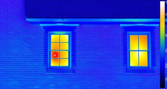

Lidar technology uses laser pulses to measure distances precisely, creating detailed 3D maps of environments. It allows you to generate accurate spatial data quickly, ideal for applications like autonomous vehicles, environmental monitoring, and urban planning. Lidar can penetrate vegetation to reveal ground surfaces and produce high-resolution models with minimal effort. As technology advances and becomes more affordable, its uses are expanding across many industries. Keep exploring to discover how lidar is transforming mapping and environmental analysis.
Key Takeaways
- Lidar uses laser pulses to generate accurate, high-resolution 3D maps of environments and terrain.
- It penetrates vegetation, revealing ground surfaces beneath forests for detailed topographical modeling.
- In autonomous vehicles, lidar creates real-time 3D representations for obstacle detection and navigation.
- Lidar enables rapid, large-scale environmental monitoring for applications like deforestation and disaster assessment.
- Advances in sensor technology are making lidar more affordable and versatile across various industries.

Lidar technology has revolutionized how we create detailed 3D maps by using laser pulses to measure distances accurately. This innovation enables us to capture precise spatial data, which plays a essential role in various fields. For instance, in the development of autonomous vehicles, lidar sensors scan the environment in real-time, providing high-resolution 3D representations of surroundings. This allows self-driving cars to detect obstacles, interpret road conditions, and navigate safely, even in challenging conditions like low light or fog. With lidar, autonomous vehicle systems can differentiate between pedestrians, other vehicles, and stationary objects with remarkable accuracy, notably improving safety and reliability on the road.
Beyond transportation, lidar technology is indispensable for environmental monitoring. By deploying lidar sensors on aircraft or drones, you can gather detailed topographical data of forests, coastlines, or urban areas. This data helps track deforestation, monitor coastal erosion, or assess the impact of natural disasters. Because lidar can penetrate through vegetation to reveal ground surfaces beneath, it provides a more complete picture of complex landscapes. Such detailed 3D maps support scientists and policymakers in making informed decisions about conservation efforts, land management, and disaster response strategies. The ability to produce accurate, high-resolution models quickly and over large areas makes lidar an essential tool for environmental monitoring.
The key advantage of lidar over traditional mapping methods is its ability to generate highly detailed 3D maps rapidly. You can collect vast amounts of spatial data with minimal effort, which can then be processed into comprehensive models. These models are important not only for autonomous vehicles and environmental monitoring but also for urban planning, archaeology, and infrastructure development. As lidar sensors become more affordable and compact, their applications continue to expand, allowing more organizations and industries to leverage this technology for better decision-making. Additionally, ongoing advancements in sensor technology are making lidar more accessible and versatile for a wide range of uses.
Top picks for "lidar technology mapp"
Open Amazon search results for this keyword.
As an affiliate, we earn on qualifying purchases.
Frequently Asked Questions
How Does Lidar Compare to Other 3D Mapping Technologies?
You’ll find that lidar outperforms many 3D mapping technologies in sensor accuracy, providing highly detailed and precise data. Unlike photogrammetry, lidar can operate effectively in low-light or complex environments. It also integrates seamlessly with other sensors, enhancing data collection. While some alternatives like radar or sonar excel in specific conditions, lidar’s accuracy and data integration capabilities make it a top choice for detailed, reliable 3D mapping.
What Are the Limitations of Lidar in Different Environments?
You’ll find that environmental interference, like rain or fog, can disrupt lidar signals, reducing accuracy. Surface reflectivity also affects performance; highly reflective surfaces create strong signals, while darker or matte surfaces may absorb or scatter the laser pulses, leading to less precise data. These limitations mean lidar works best in clear conditions and on surfaces with good reflectivity, but struggles in adverse weather or with certain materials.
How Is Lidar Data Processed Into Usable 3D Maps?
Transforming lidar data into detailed 3D maps takes meticulous point cloud processing and clever data fusion. First, you clean and organize the point cloud, removing noise and filling gaps. Then, you align multiple datasets, blending data from various sensors. This combination creates coherent, accurate, and extensive 3D maps, letting you visualize environments vividly. This process empowers precise planning, navigation, and analysis, turning raw data into real-world relevance.
What Are the Future Developments in Lidar Technology?
You’ll see lidar technology advancing to improve autonomous vehicles’ safety and environmental monitoring accuracy. Future developments include higher resolution sensors, faster data processing, and miniaturization for easier integration. These improvements will enable more precise object detection, better navigation, and real-time environmental data collection. As a result, autonomous driving becomes safer, and environmental monitoring becomes more extensive, helping you better understand and protect our planet.
How Cost-Effective Is Lidar for Large-Scale Mapping Projects?
Imagine scanning vast landscapes effortlessly—lidar can be quite cost-effective for large-scale mapping if you do a thorough cost analysis and consider your budget. While upfront expenses might seem high, the efficiency and accuracy it offers often reduce long-term costs. You’ll find that with careful planning and selecting suitable equipment, lidar becomes a valuable investment, especially for extensive projects where precision saves time and resources.
Conclusion
You might think lidar tech is too complex or expensive to use, but it’s actually more accessible than ever. With its ability to create detailed 3D maps quickly, you can see how it transforms industries like navigation, construction, and even gaming. Don’t let the technical jargon scare you off—once you understand its power, you’ll realize lidar makes mapping easier, faster, and more precise. Embrace this innovation and see how it can elevate your projects!